|
|

|
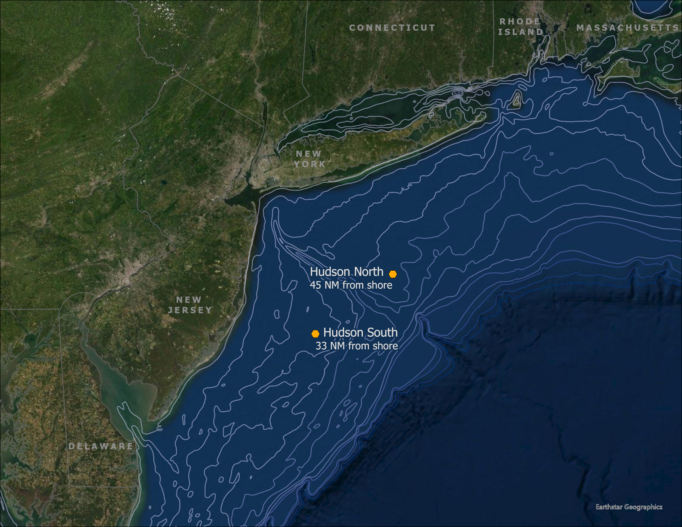
Offshore Wind and Environmental Data A strong knowledge of meteorological and oceanographic – metocean – conditions is essential for the safe and efficient design and operation of offshore wind installations. Wind speed data and other conditions have been modeled for the New York Bight; however, only limited metocean data has been collected in the region. There is a general lack of wind speed measurements off the northeastern coast of the U.S. This data is critical for the development of offshore wind projects as it provides developers the necessary oceanographic and meteorological conditions to assess the amount of energy an offshore wind farm will produce. Better metocean characterization of the wind, wave, and ocean currents will also help increase certainty of development conditions which is valuable information for planning project layout, turbine siting and engineering. More efficient design of offshore wind sites will help maximize renewable energy output, delivering more clean energy to the electric grid in a smaller physical and environmental footprint. The deployment of metocean buoys also presents an opportunity to collect continuous monitoring wildlife data to fill data gaps in the temporal and spatial use of the offshore region by wildlife. Through competitive solicitation, NYSERDA has contracted Ocean Tech Services to supply and deploy two floating LiDAR (light detection and ranging) buoys in the New York Bight in the summer of 2019 for a period of two-years. Normandeau Associates is working with Ocean Tech to analyze and make the wildlife data collected by the buoys available through this website. This includes data collected by passive acoustic mircophones to detect vocalizations by birds and bats, nanotag receivers to detect tagged birds and fishes, and hydrophones to detect vocalizations marine mammals. In October 2021, after two years of data collection, the Hudson North buoy was recovered (Figure 1). In February 2022, a new buoy was installed in Hudson South (Figure 2) and in April 2022, the original Hudson South buoy was recovered (Figure 1). The Hudson North buoy is at 57 meters depth. The Hudson South Buoy first location was at 32 meters depth. The current, second location of the Hudson South Buoy is at 33 meters depth. |
Offshore Metocean Data DNV GL is working with Ocean Tech and will provide analysis of the metocean data from the buoys, to store the data, and make the data publicly available. Each of the buoys will measure turbine hub-height wind speed and direction, wave and current measurements, as well as the environmental and wildlife data. Both buoys have been validated to meet or exceed industry performance standards, including validation to the Carbon Trust OWA Stage 2 Standard and the IEC Standard 614700-12-1 CDV. More information, including the metocean data itself is being made available via the DNV GL Resource Panorama data platform. The metaocean buoys are carrying 5 additional sensors: Download Buoy Sensor Spec Sheets 1. Nanotag Antennas (Lotek SRX 800 VHF Radio Receiver) (Buoy) Nanotag antennas provide species-specific information gleaned from tagged birds. In collaboration with FWS, information shared will include tagged endangered species including Red Knot, Piping Plover and Roseate Tern. 2. Bird Acoustic Sensor (Wildlife Acoustics Song Meter SM4 Acoustic Recorder) (Buoy) Bird acoustic sensors constantly record diurnal and nocturnal bird calls and will help fill data gaps for spring and fall migrant passerines in particular, including warblers, grosbeaks, buntings, pipits, thrushes and redstarts. 3. Bat Ultrasonic Sensor (Wildlife Acoustics Song Meter SM4BAT FS Ultrasonic Recorder) (Buoy) Bat acoustic sensors record migrating bat calls. Migrating bat species commonly occur in August and September and include Eastern Red Bat, Hoary Bat, and Silver-haired Bat. 4. Underwater Acoustic Recorder (Loggerhead Instruments LS1 Acoustic Sensors) (Seabed) Underwater acoustic recorders record vocalizations of marine mammals and some fish. 5. VEMCO Fish Tag Receivers (VEMCO VR2W Single Channel Receiver) (Seabed) VEMCO single channel receivers record species-specific information on tagged fish in the area. |
Figure 1. Original Hudson North and South Buoy locations 2019-2022 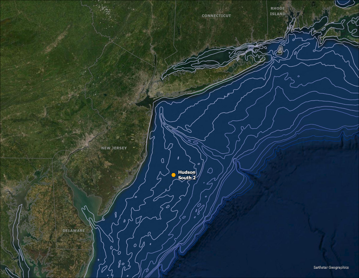 Figure 2. Second Hudson South Buoy location installed February 2022 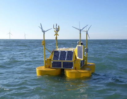 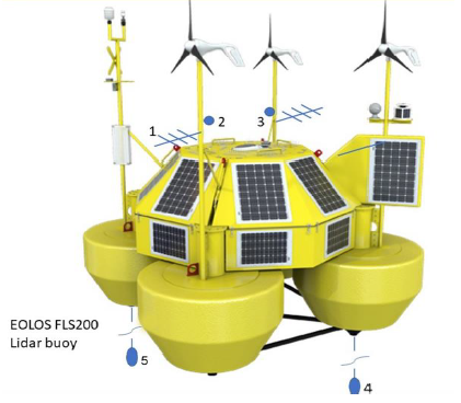
|
.jpg)