|
|
|
Remote Marine and Onshore Technology (ReMOTe) is Normandeau's secure, real-time data portal. ReMOTe provides the ability to access, analyze, and visualize a variety of species information in a secure, user-friendly platform. ReMOTe provides real-time outputs as well as details on how data was accessed and analyzed. Data TypesInitially developed for Normandeau's bat acoustic data and our high-resolution aerial imaging data, ReMOTe is also suitable for species data collected by other methods, including visual and acoustic data collected via commercial or client-specific methods. Uploaded data are stored at our secure data management center. AccessAccess to data through ReMOTe is project-specific. Data can be public, restricted, or a combination of both depending on client needs. Outputs are customizable depending on client needs. AnalyzeAs data are analyzed, ReMOTe records all changes made by each analyst, thus ensuring total traceability and allowing easy and transparent tracking of progress and quality control. Data are updated in real time as analyses are completed. VisualizeData and metadata are displayed in the most appropriate format for the project purpose and type of data collected. Georeferenced image data are often displayed in an interactive map, with associated identifications, metadata, and tabular reports available at the click of a mouse. Who we areOcean Tech Services LLC (OTS) was formed in 2007 to address the need for specialized services and support in the marine monitoring and offshore operations industry. OTS provides marine environmental measurement and offshore operational support to a wide range of industries. OTS customers include marine contractors, offshore wind developers, port and harbor managers, Government agencies, and research institutions. With decades of experience designing and executing offshore marine projects around the world, OTS has a solid reputation for delivering quality performance and results and building long-lasting professional relationships with customers. Normandeau Associates, Inc., is a highly regarded U.S. environmental consultancy offering innovative solutions to data needs and is recognized as a national leader in providing science-based environmental consulting services, research, and technological innovation across a biological spectrum. Normandeau's highly qualified scientists have worked together for over 25 years, providing high-caliber technical capabilities and solutions. Specialized technical expertise for offshore wind developments, including extensive experience with remote sensing using high-resolution aerial photography and acoustic data, is essential for projects in remote areas or with limited access. Ocean Tech‐Normandeau have teamed up to offer wildlife surveys for successful permitting of offshore wind farms in the U.S., including analyzing and making the wildlife data collected by the buoys available through ReMOTe.normandeau.com. This includes data collected by passive acoustic microphones to detect vocalizations by birds and bats, nanotag receivers to detect tagged birds and fishes, and hydrophones to detect vocalizations of marine mammals. The Ocean Tech‐Normandeau team combines extensive knowledge of innovative technology and methods with scientific integrity and regulatory experience, providing a new standard for gathering offshore wildlife data in North America. Our approach is to work with you to design a cost-effective solution based on the unique needs of your project. The process begins with clearly defined scientific-study designs created by the Ocean Tech-Normandeau team. We offer flexible equipment options to meet project-specific requirements. We also provide expert scientific identification of wildlife presence and activity at offshore project areas. Solid, reliable results to inform your decisions. We are pleased to provide an array of meteorological and oceanographic data collection systems using calibrated sensors and proven remote communications to deliver high quality data to our customers. We work closely with our product partners to design the most appropriate and cost-effective data collection systems based on our customers' project specifics and data needs. Our experienced personnel will provide complete turn-key services for sampling strategies, mooring design, installation, maintenance, and daily performance monitoring. Primary data collection areas include:
Using the biological acoustic data collected from a suite of sensors, Normandeau analyzes the information and makes the results available on ReMOTe.normandeau.com. Advantages of metocean dataEach biological data set may be provided with supplemental environmental data characterizing site-specific conditions during the program. An understanding of the wind, air temperature, water temperature, waves, currents and other variables may prove valuable in better understanding the presence and behavior of wildlife throughout the seasons. ServicesThe Ocean Tech‐Normandeau team can undertake specific parts of an environmental project or handle the entire work package from beginning to end. Your project will have access to top scientific specialists, making the Ocean Tech‐Normandeau team the obvious choice for a host of existing and new scientific studies. Metocean BuoysA strong knowledge of meteorological and oceanographic (metocean) conditions is essential for the safe and efficient design and operation of offshore wind installations. Wind speed data and other conditions have been modeled for the New York Bight; however, only limited metocean data have been collected in the region. These data are critical for developing offshore wind projects as it provides developers the necessary oceanographic and meteorological information required to assess the wind energy potential, and to provide data required for structural design of an offshore windfarm. Characterization of the wind, wave, and ocean currents will also help increase certainty of development conditions, which is valuable information for planning project layout, turbine siting, and engineering. The deployment of metocean buoys also presents an opportunity to collect continuous wildlife data to fill data gaps in the temporal and spatial use of the offshore region by wildlife. Floating LiDAR and traditional weather buoys are used by Ocean Tech‐Normandeau to host atmospheric, oceanographic, and biological sensor systems. Each buoy is specifically fitted with the sensor packages required by customers for a specific project area. A full suite of environmental and biological data collection is offered through additional sensor packages deployed on the buoy/Trawl-Resistant Bottom Mount (TRBM) both day and night and above and below the ocean's surface:
|
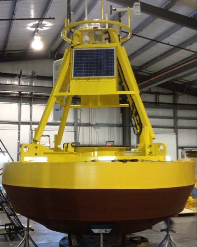 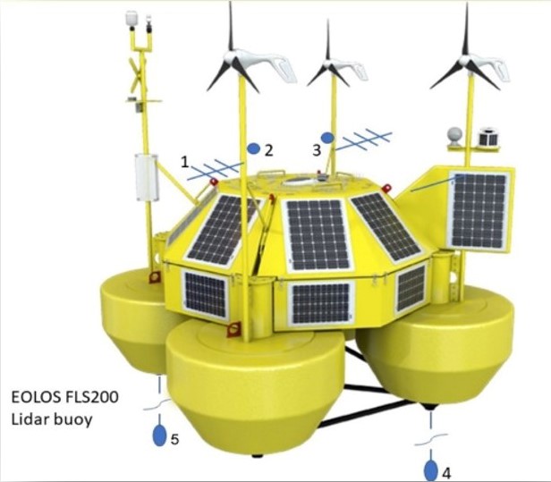 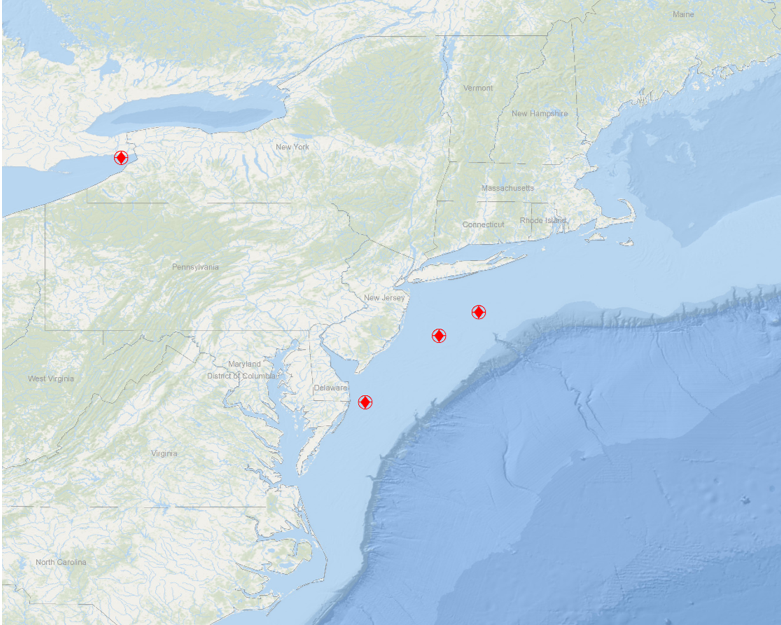 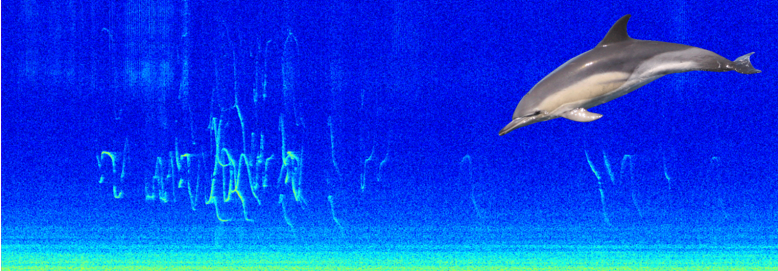 Figure 1. Dolphin Call
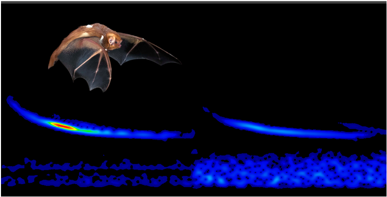 Figure 2. Bat Call
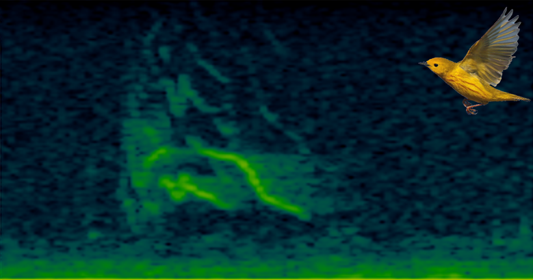 Figure 3. Yellow Warbler Call
 |
.jpg)